| |
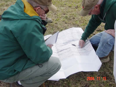
Longwall mining damage image of James Kinney Farmstead. This subsidence
crack is located in the pasture/hayfield along Harts road. This
picture shows Dave Clark, ODNR-DMR from Cambride, OH office (left)
and Tom Pulay (right) also of ODNR-DMR local fleld man. They are
looking at the coal company's "panel map" that shows the
exact location of the panels that were mined under the area. They
agreed that the 160 foot by 6 inch crack was from longwall mining
and resulted from a cave in of the gate between two panels. One
panel went through Christmas 2003 and the one tht went next to it
in July 2004. The gate road is an underground road which is built
between longwall panels for the transfer of coal, men and equipment
during the mining process. This is the kind of proposed gate road
described in OVCC's testimony for Dysart Woods that “would
never cave in”. Two of these have caved in under Country Mile
Farm property in the last year.
|